Signal No. 5 up in Babuyan Islands as ‘Goring’ reintensifies into super typhoon | ABS-CBN


Welcome, Kapamilya! We use cookies to improve your browsing experience. Continuing to use this site means you agree to our use of cookies. Tell me more!
Signal No. 5 up in Babuyan Islands as ‘Goring’ reintensifies into super typhoon
Signal No. 5 up in Babuyan Islands as ‘Goring’ reintensifies into super typhoon
ABS-CBN News
Published Aug 30, 2023 12:17 AM PHT
|
Updated Aug 30, 2023 02:04 PM PHT
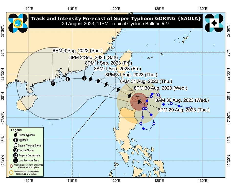
MANILA - The state weather bureau warned of violent, life-threatening conditions in Babuyan Islands as typhoon Goring (international name: Saola) reintensified into a super typhoon late Tuesday.
MANILA - The state weather bureau warned of violent, life-threatening conditions in Babuyan Islands as typhoon Goring (international name: Saola) reintensified into a super typhoon late Tuesday.
In its 11 p.m. weather bulletin, PAGASA said Goring was spotted over the coastal waters of Calayan (Babuyan Islands), Cagayan, packing maximum sustained winds of 185 kilometers per hour near the center, with gusts of up to 230 kph.
In its 11 p.m. weather bulletin, PAGASA said Goring was spotted over the coastal waters of Calayan (Babuyan Islands), Cagayan, packing maximum sustained winds of 185 kilometers per hour near the center, with gusts of up to 230 kph.
It is currently moving northwestward at 10 kph, and is expected to continue moving in the same direction across the Luzon Strait until it exits the Philippine area of responsibility.
It is currently moving northwestward at 10 kph, and is expected to continue moving in the same direction across the Luzon Strait until it exits the Philippine area of responsibility.
PAGASA also said Goring may pass very close or make landfall in the vicinity of Babuyan Island between Tuesday night to Wednesday afternoon.
PAGASA also said Goring may pass very close or make landfall in the vicinity of Babuyan Island between Tuesday night to Wednesday afternoon.
ADVERTISEMENT
Tropical Cyclone Wind Signal No. 5, wherein typhoon-force winds pose extreme threat to life and property, has been raised over the northeastern portion of Babuyan Islands.
Tropical Cyclone Wind Signal No. 5, wherein typhoon-force winds pose extreme threat to life and property, has been raised over the northeastern portion of Babuyan Islands.
Signal No. 4, on the other hand, was hoisted over the southern portion of Batanes (Sabtang, Uyugan, Ivana, Mahatao, Basco) and the northwestern and southeastern portions of Babuyan Islands (Camiguin Is., Calayan Is.).
Signal No. 4, on the other hand, was hoisted over the southern portion of Batanes (Sabtang, Uyugan, Ivana, Mahatao, Basco) and the northwestern and southeastern portions of Babuyan Islands (Camiguin Is., Calayan Is.).
Goring may dump greater than 200 millimeter of rainfall over Babuyan Islands and Batanes until Wednesday evening.
Goring may dump greater than 200 millimeter of rainfall over Babuyan Islands and Batanes until Wednesday evening.
"Under these conditions, flooding and rain-induced landslides are possible especially in areas that are highly or very highly susceptible to these hazards," PAGASA warned.
"Under these conditions, flooding and rain-induced landslides are possible especially in areas that are highly or very highly susceptible to these hazards," PAGASA warned.
Goring will also enhance the southwest monsoon, which will bring occasional rains over the western portions of Central Luzon, Southern Luzon, and Visayas over the next three days, PAGASA said.
Goring will also enhance the southwest monsoon, which will bring occasional rains over the western portions of Central Luzon, Southern Luzon, and Visayas over the next three days, PAGASA said.
PAGASA also raised the following winds signals.
PAGASA also raised the following winds signals.
Signal No. 3
- Rest of Batanes
- Rest of Babuyan Islands
- Extreme northeastern portion of mainland Cagayan (Santa Ana)
- Rest of Batanes
- Rest of Babuyan Islands
- Extreme northeastern portion of mainland Cagayan (Santa Ana)
Signal No. 2
- Nnorthern and eastern portions of mainland Cagayan (Gonzaga, Santa Praxedes, Claveria, Sanchez-Mira, Pamplona, Abulug, Ballesteros, Aparri, Buguey, Camalaniugan, Santa Teresita, Allacapan, Lal-Lo, Lasam, Gattaran, Baggao, Peñablanca)
- Northern portion of Ilocos Norte (Pagudpud, Adams, Bangui, Dumalneg)
- Northern portion of Apayao (Calanasan, Luna, Santa Marcela, Flora, Pudtol)
Signal No. 1
- Northern and eastern portion of Isabela (Dinapigue, San Mariano, Ilagan City, Tumauini, San Pablo, Cabagan, Maconacon, Divilacan, Palanan, Santa Maria, Santo Tomas, Quezon, Delfin Albano)
- Rest of Ilocos Norte
- Rest of Cagayan
- Rest of Apayao
- Northern portion of Abra (Tineg, Lagayan, Lacub, Malibcong)
- Northern portion of Kalinga (Balbalan, Pinukpuk, Rizal, City of Tabuk)
PAGASA said Goring is forecast to exit the Philippine area of responsibility between Wednesday evening or Thursday morning.
PAGASA said Goring is forecast to exit the Philippine area of responsibility between Wednesday evening or Thursday morning.
Meanwhile, the tropical storm outside of PAR, with the international name Haikui, slightly intensified over the Philippine Sea.
Meanwhile, the tropical storm outside of PAR, with the international name Haikui, slightly intensified over the Philippine Sea.
As of 10 a.m., it is located 1,660 kilometers east of extreme northern Luzon.
As of 10 a.m., it is located 1,660 kilometers east of extreme northern Luzon.
PAGASA said it may enter PAR by Wednesday morning and will be assigned the local name “Hanna.”
PAGASA said it may enter PAR by Wednesday morning and will be assigned the local name “Hanna.”
It is forecast to remain far from the Philippine landmass and may exit PAR by Friday.
It is forecast to remain far from the Philippine landmass and may exit PAR by Friday.
Although it is less likely to directly affect the country, PAGASA said it may enhance the habagat beginning Wednesday or Thursday, and may bring occasional or monsoon rains over the western portion of Luzon and Visayas.
Although it is less likely to directly affect the country, PAGASA said it may enhance the habagat beginning Wednesday or Thursday, and may bring occasional or monsoon rains over the western portion of Luzon and Visayas.
For more updates, visit the ABS-CBN weather center.
RELATED VIDEO
ADVERTISEMENT
ADVERTISEMENT