Storm surge, floods likely as cyclone Crising ferments off Cagayan


ADVERTISEMENT

Welcome, Kapamilya! We use cookies to improve your browsing experience. Continuing to use this site means you agree to our use of cookies. Tell me more!
Storm surge, floods likely as cyclone Crising ferments off Cagayan
Jojo Pasion Malig,
ABS-CBN News
Published Jul 18, 2025 11:55 PM PHT
 Himawari-9/RAMBB satellite imagery
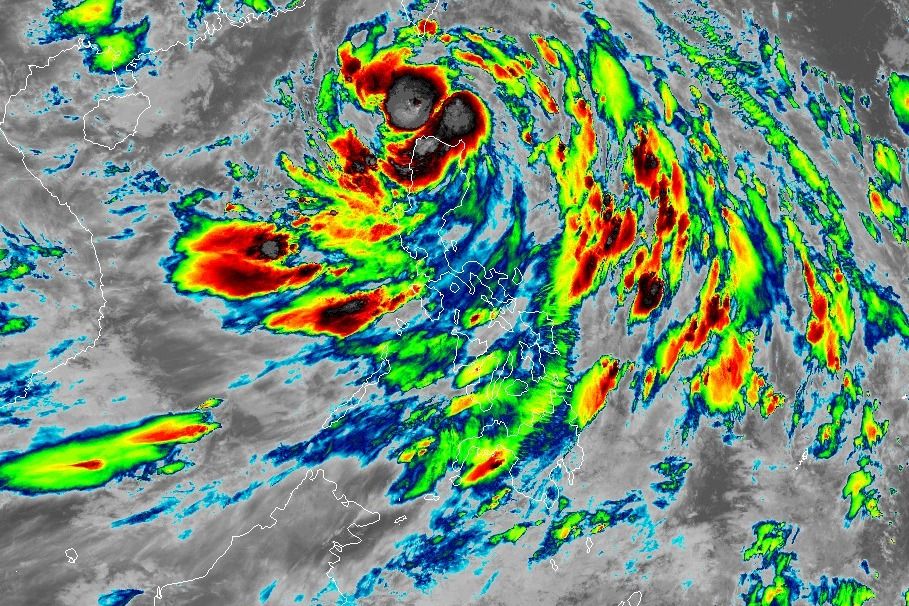
Himawari-9/RAMBB satellite imageryMANILA - Tropical Storm Crising may trigger storm surge and floods in various parts of the country as it moved over the coastal waters of Calayan, Cagayan province Friday night, the state weather bureau warned.
MANILA - Tropical Storm Crising may trigger storm surge and floods in various parts of the country as it moved over the coastal waters of Calayan, Cagayan province Friday night, the state weather bureau warned.
Packing 75 kilometers per hour winds and gusts reaching 105 kph, the tropical cyclone may spawn life-threatening storm surge with peak heights reaching 1 to 2 meters in coastal areas of Batanes, Cagayan including Babuyan Islands, Ilocos Norte, and Ilocos Sur, PAGASA said Friday.
Packing 75 kilometers per hour winds and gusts reaching 105 kph, the tropical cyclone may spawn life-threatening storm surge with peak heights reaching 1 to 2 meters in coastal areas of Batanes, Cagayan including Babuyan Islands, Ilocos Norte, and Ilocos Sur, PAGASA said Friday.
Meanwhile, a combination of the tropical storm and the southwest monsoon or habagat may cause heavy rainfall reaching 200mm in Cagayan, Apayao, Abra, Ilocos Norte, and Ilocos Sur from Friday night to Saturday night, PAGASA added.
Meanwhile, a combination of the tropical storm and the southwest monsoon or habagat may cause heavy rainfall reaching 200mm in Cagayan, Apayao, Abra, Ilocos Norte, and Ilocos Sur from Friday night to Saturday night, PAGASA added.
Around 100-200 mm rainfall is forecast in Batanes, Isabela, Benguet, Kalinga, Mountain Province, Ifugao, La Union, and Pangasinan; while 50-100 mm rainfall is expected to drench Nueva Vizcaya and Quirino.
Around 100-200 mm rainfall is forecast in Batanes, Isabela, Benguet, Kalinga, Mountain Province, Ifugao, La Union, and Pangasinan; while 50-100 mm rainfall is expected to drench Nueva Vizcaya and Quirino.
ADVERTISEMENT
The weather bureau has raised Tropical Cyclone Wind Signal No. 2 over the following areas that may experience gale-force winds: Batanes, Cagayan including Babuyan Islands, Isabela, Apayao, Kalinga, the northern and central portions of Abra (Manabo, Pidigan, San Juan, Tayum, Langiden, Boliney, Sallapadan, Bucloc, Lagangilang, Danglas, La Paz, Licuan-Baay, Tineg, Malibcong, Peñarrubia, San Isidro, Daguioman, San Quintin, Dolores, Lagayan, Bangued, Bucay, Lacub), the eastern portion of Mountain Province (Natonin, Paracelis), the eastern portion of Ifugao (Aguinaldo, Alfonso Lista), Ilocos Norte, and the northern portion of Ilocos Sur (Cabugao, Sinait, Magsingal, San Juan, San Ildefonso, Santo Domingo, Bantay, San Vicente, Santa Catalina, Caoayan, City of Vigan, Santa)
The weather bureau has raised Tropical Cyclone Wind Signal No. 2 over the following areas that may experience gale-force winds: Batanes, Cagayan including Babuyan Islands, Isabela, Apayao, Kalinga, the northern and central portions of Abra (Manabo, Pidigan, San Juan, Tayum, Langiden, Boliney, Sallapadan, Bucloc, Lagangilang, Danglas, La Paz, Licuan-Baay, Tineg, Malibcong, Peñarrubia, San Isidro, Daguioman, San Quintin, Dolores, Lagayan, Bangued, Bucay, Lacub), the eastern portion of Mountain Province (Natonin, Paracelis), the eastern portion of Ifugao (Aguinaldo, Alfonso Lista), Ilocos Norte, and the northern portion of Ilocos Sur (Cabugao, Sinait, Magsingal, San Juan, San Ildefonso, Santo Domingo, Bantay, San Vicente, Santa Catalina, Caoayan, City of Vigan, Santa)
Tropical Cyclone WInd Signal No. 1 has also been hoisted over the following areas that may experience strong winds: Quirino, Nueva Vizcaya, the rest of Mountain Province, the rest of Ifugao, the rest of Abra, Benguet, the rest of Ilocos Sur, La Union, the northern portion of Pangasinan (San Nicolas, Natividad, San Quintin, San Manuel, Tayug, Sison, San Fabian, Pozorrubio, Laoac, Binalonan, San Jacinto, Manaoag, Mangaldan, Dagupan City, Binmaley, Lingayen, Labrador, Sual, City of Alaminos, Bolinao, Anda, Bani, Agno, Burgos, Mabini, Dasol, Calasiao, Santa Barbara, Mapandan, Bugallon), the northern portion of Aurora (Dilasag, Casiguran, Dinalungan, Dipaculao, Baler, Maria Aurora), and the northeastern portion of Nueva Ecija (Carranglan, Pantabangan).
Tropical Cyclone WInd Signal No. 1 has also been hoisted over the following areas that may experience strong winds: Quirino, Nueva Vizcaya, the rest of Mountain Province, the rest of Ifugao, the rest of Abra, Benguet, the rest of Ilocos Sur, La Union, the northern portion of Pangasinan (San Nicolas, Natividad, San Quintin, San Manuel, Tayug, Sison, San Fabian, Pozorrubio, Laoac, Binalonan, San Jacinto, Manaoag, Mangaldan, Dagupan City, Binmaley, Lingayen, Labrador, Sual, City of Alaminos, Bolinao, Anda, Bani, Agno, Burgos, Mabini, Dasol, Calasiao, Santa Barbara, Mapandan, Bugallon), the northern portion of Aurora (Dilasag, Casiguran, Dinalungan, Dipaculao, Baler, Maria Aurora), and the northeastern portion of Nueva Ecija (Carranglan, Pantabangan).
The southwest monsoon is also forecast to bring strong to gale-force gusts over the following areas on Saturday: Metro Manila, Pangasinan, Central Luzon, CALABARZON, MIMAROPA, Bicol Region, Visayas, Zamboanga Peninsula, Basilan, Sulu, Tawi-Tawi, Misamis Occidental, Lanao del Norte, Camiguin, Dinagat Islands, Davao Occidental, and Davao Oriental.
The southwest monsoon is also forecast to bring strong to gale-force gusts over the following areas on Saturday: Metro Manila, Pangasinan, Central Luzon, CALABARZON, MIMAROPA, Bicol Region, Visayas, Zamboanga Peninsula, Basilan, Sulu, Tawi-Tawi, Misamis Occidental, Lanao del Norte, Camiguin, Dinagat Islands, Davao Occidental, and Davao Oriental.
 PAGASA forecast track of Tropical Storm Crising
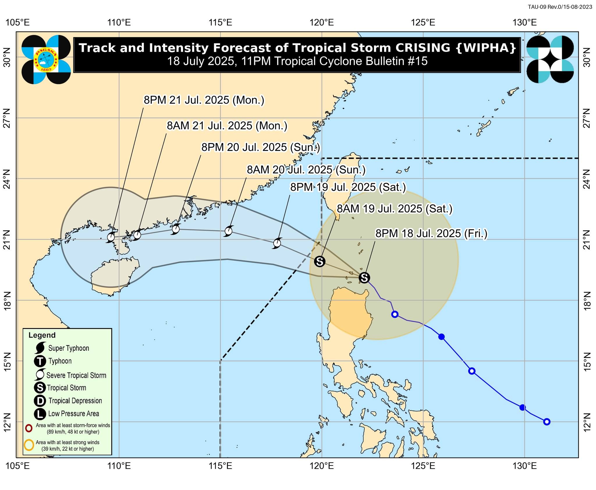
PAGASA forecast track of Tropical Storm CrisingThe center of Crising was last spotted over the coastal waters of Calayan, Cagayan as of 10 p.m. and was moving northwestward at 15 kph.
The center of Crising was last spotted over the coastal waters of Calayan, Cagayan as of 10 p.m. and was moving northwestward at 15 kph.
It is expected to continue to intensify until it reaches Severe Tropical Storm category by Saturday evening or Sunday morning.
It is expected to continue to intensify until it reaches Severe Tropical Storm category by Saturday evening or Sunday morning.
PAGASA said it is now less likely to make landfall over the Babuyan Islands, and will continue to move west-northwestward, traversing extreme Northern Luzon until it exits the Philippine Area of Responsibility by Saturday morning.
PAGASA said it is now less likely to make landfall over the Babuyan Islands, and will continue to move west-northwestward, traversing extreme Northern Luzon until it exits the Philippine Area of Responsibility by Saturday morning.
ADVERTISEMENT
ADVERTISEMENT