Welcome, Kapamilya! We use cookies to improve your browsing experience. Continuing to use this site means you agree to our use of cookies. Tell me more!
LPA off Mindanao now Tropical Depression Vicky; Signal no. 1 up in several areas
LPA off Mindanao now Tropical Depression Vicky; Signal no. 1 up in several areas
ABS-CBN News
Published Dec 18, 2020 07:14 AM PHT
|
Updated Dec 18, 2020 01:48 PM PHT
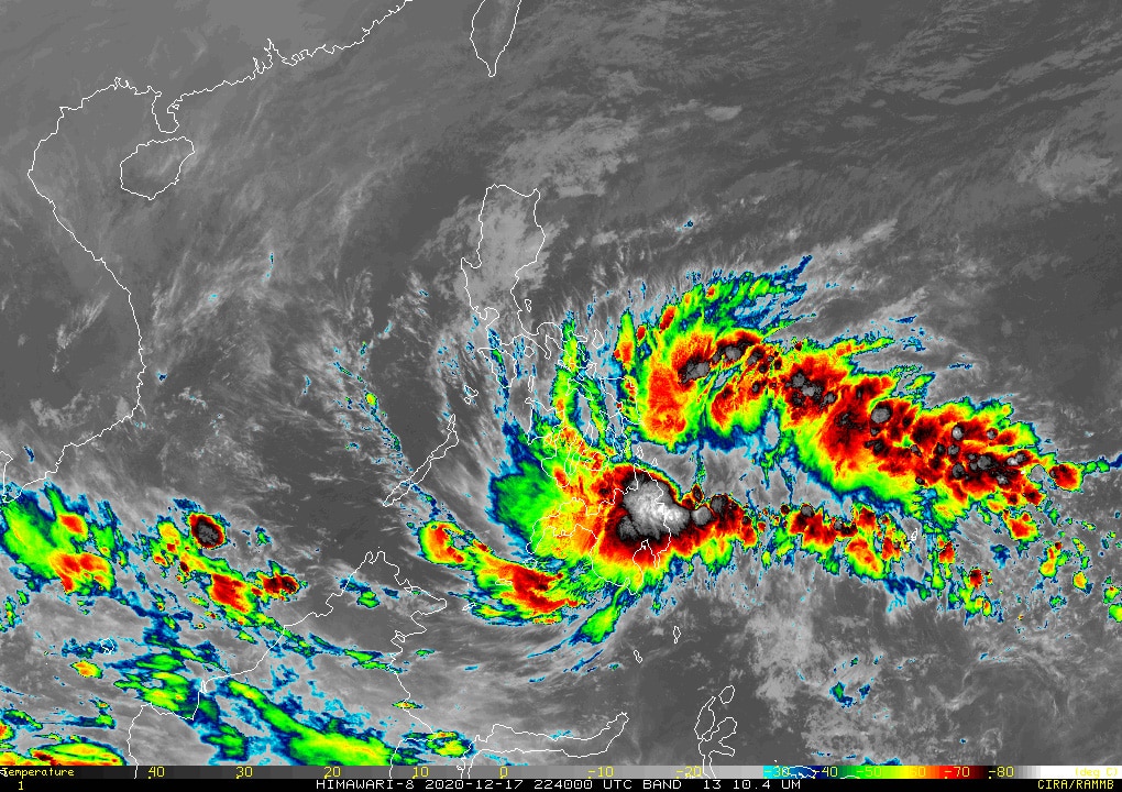
Courtesy of Japanese Meteorological Agency
MANILA (2nd UPDATE) - A low-pressure area (LPA) east of Mindanao developed into Tropical Depression Vicky early Friday, the state weather bureau PAGASA said.
Tropical cyclone wind signal number 1 was raised over many parts of the country ahead of Vicky's approach, warning of strong breeze to near gale conditions.
PAGASA said the weather disturbance intensified into tropical depression at 2 a.m. It is the 22nd tropical cyclone to enter the country this year following typhoon Ulysses in November, which devastated many parts of Luzon, including Metro Manila.
In its 8 a.m. bulletin, the agency said Vicky was last spotted at 185 kilometers east of Davao City. It is still packing maximum sustained winds of 45 kilometers per hour (kph) near the center and gustiness of up to 55 kph.
ADVERTISEMENT
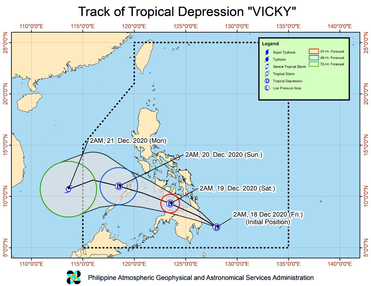
Moving west-northwest at 15 kph, it is forecast to hit land between Davao Oriental and Surigao del Sur in the next 12 hours.
After crossing Mindanao, the tropical depression is likely to emerge over the Bohol Sea early Saturday morning, PAGASA said.
Vicky may pass close or over Siquijor, and make another landfall over the southern portion of Negros Island. By Sunday morning or afternoon, it is likely to emerge off the Sulu Sea, the agency added.
Tropical cyclone wind signal number 1 remains hoisted over the following areas, where 30 to 60 kph winds may rip roofs off nipa and cogon huts, damage rice crops and down banana plants:
Luzon
northern and central portion of Palawan (Puerto Princesa City, Roxas, San Vicente, Dumaran, Araceli, Taytay, El Nido) including Calamian, Cuyo, and Cagayancillo Islands
Visayas
southern portion of Leyte (Baybay City, Javier, Abuyog, Mahaplag, Inopacan, Hindang, Hilongos, Bato, Matalom, Palompon, Merida, Isabel)
Southern Leyte
central and southern portions of Cebu (Borbon, Tabuelan, Tuburan, Sogod, Catmon, Carmen, Asturias, Danao City, Compostela, Liloan, Consolacion, Mandaue City, LapuLapu City, Cordoba, Balamban, Cebu City, Talisay City, Toledo City, Minglanilla, Naga City, Pinamungahan, San Fernando, Aloguinsan, Carcar, Barili, Sibonga, Dumanjug, Ronda, Alcantara, Moalboal, Argao, Dalaguete, Badian, Alegria, Alcoy, Boljoon, Oslob, Malabuyoc, Ginatilan, Samboan, Santander) including Camotes Islands
Bohol
Siquijor
Negros Oriental
Negros Occidental
Guimaras
central and southern portions of Iloilo (Ajuy, Barotac Viejo, San Enrique, San Rafael, Passi City, Bingawan, Calinog, Lambunao, Janiuay, Banate, Anilao, Dingle, Duenas, Badiangan, Barotac Nuevo, Zarraga, Pototan, Dumangas, Mina, New Lucena, Santa Barbara, Leganes, Iloilo City, Pavia, Cabatuan, Maasin, Alimodian, San Miguel, Leon, Oton, Tigbauan, Tubungan, Guimbal, Igbaras, Miagao, San Joaquin)
southern portion of Antique (Valderrama, San Remigio, Sibalom, Hamtic, Tobias Fornier, AniniY, Bugasong, LauaAn, Patnongon, San Jose, Belison)
Mindanao
Dinagat Islands
Surigao del Norte
Surigao del Sur
Agusan del Norte
Agusan del Sur
Davao Oriental
Davao del Norte
Davao de Oro
Davao City
northern portion of Davao del Sur (Santa Cruz, Digos City, Bansalan, Magsaysay, Matanao, Hagonoy)
Camiguin
Bukidnon
Misamis Oriental
Misamis Occidental
Lanao del Norte
Lanao del Sur
Maguindanao
Cotabato City
North Cotabato
Zamboanga del Sur
Zamboanga Sibugay
northern portion of Zamboanga del Norte (Baliguian, Gutalac, Kalawit, Labason, Tampilisan, Liloy, Salug, Bacungan, Godod, Sindangan, Siayan, Jose Dalman, Manukan, Sergio Osmena Sr., Pres. Manuel A. Roxas, Katipunan, Dipolog City, Polanco, Pinan, Mutia, La Libertad, Dapitan City, Sibutad, Rizal)
Courtesy of PAGASA
HEAVY RAINFALL
PAGASA said the combined Vicky and the tail-end of a frontal system would bring moderate to heavy with at times intense rains on Friday over Caraga, Davao Oriental, Davao de Oro, Davao del Norte, Bukidnon, Misamis Oriental, Camiguin, Southern Leyte, Leyte and Bohol.
ADVERTISEMENT
Light to moderate with at times heavy rains will be experienced over Bicol Region, the southern portion of Quezon, Lanao del Sur, Zamboanga del Norte, and the rest of Visayas, Davao Region and Northern Mindanao.
PAGASA warned that flooding and rain-induced landslides may occur during heavy or prolonged periods of rainfall, especially in areas identified to be highly or very highly susceptible to these hazards and in localities that received significant antecedent rainfall over the past couple of days or weeks.
Adjacent or nearby areas may also experience flooding in the absence of such rainfall occurrence due to surface runoff or swelling of river channels, it added.
Meanwhile, the combined effects of the surge of the northeast monsoon or amihan and Vicky will bring rough to very rough seas from 2.5 meters to 4.5 meters over the entire seaboards of Northern Luzon, the seaboard of Aurora, the eastern seaboard of Quezon including Polillo Islands, the seaboard of Camarines Norte, the northern seaboard of Camarines Sur, the northern and eastern seaboards of Catanduanes, the eastern seaboard of Albay including Rapu-Rapu Islands, the eastern seaboard of Sorsogon, the northern and eastern seaboards of Northern Samar, and the eastern seaboard of Eastern Samar including Homonhon Island.
The amihan may also bring cloudy skies with rains Metro Manila, Cagayan Valley, Cordillera Administrative Region, Calabarzon, Aurora and the rest of Luzon.
Ulysses also caused catastrophic floods in the Philippine capital region in scenes reminiscent of unprecedented flooding brought by Tropical Storm Ondoy over a decade ago.
ABS-CBN is the leading media and entertainment company in the Philippines, offering quality content across TV, radio, digital, and film. Committed to public service and promoting Filipino values, ABS-CBN continues to inspire and connect audiences worldwide.
Our website is made possible by displaying online
advertisements to our visitors. Please consider supporting
us by disabling your ad blocker on our website.
Our website is made possible by displaying online
advertisements to our visitors. Please consider supporting
us by disabling your ad blocker on our website.