Typhoon Rolly, 2020's strongest tropical cyclone, barrels closer to Bicol | ABS-CBN


ADVERTISEMENT

Welcome, Kapamilya! We use cookies to improve your browsing experience. Continuing to use this site means you agree to our use of cookies. Tell me more!
Typhoon Rolly, 2020's strongest tropical cyclone, barrels closer to Bicol
Typhoon Rolly, 2020's strongest tropical cyclone, barrels closer to Bicol
ABS-CBN News
Published Oct 31, 2020 07:10 AM PHT
|
Updated Oct 31, 2020 10:26 AM PHT
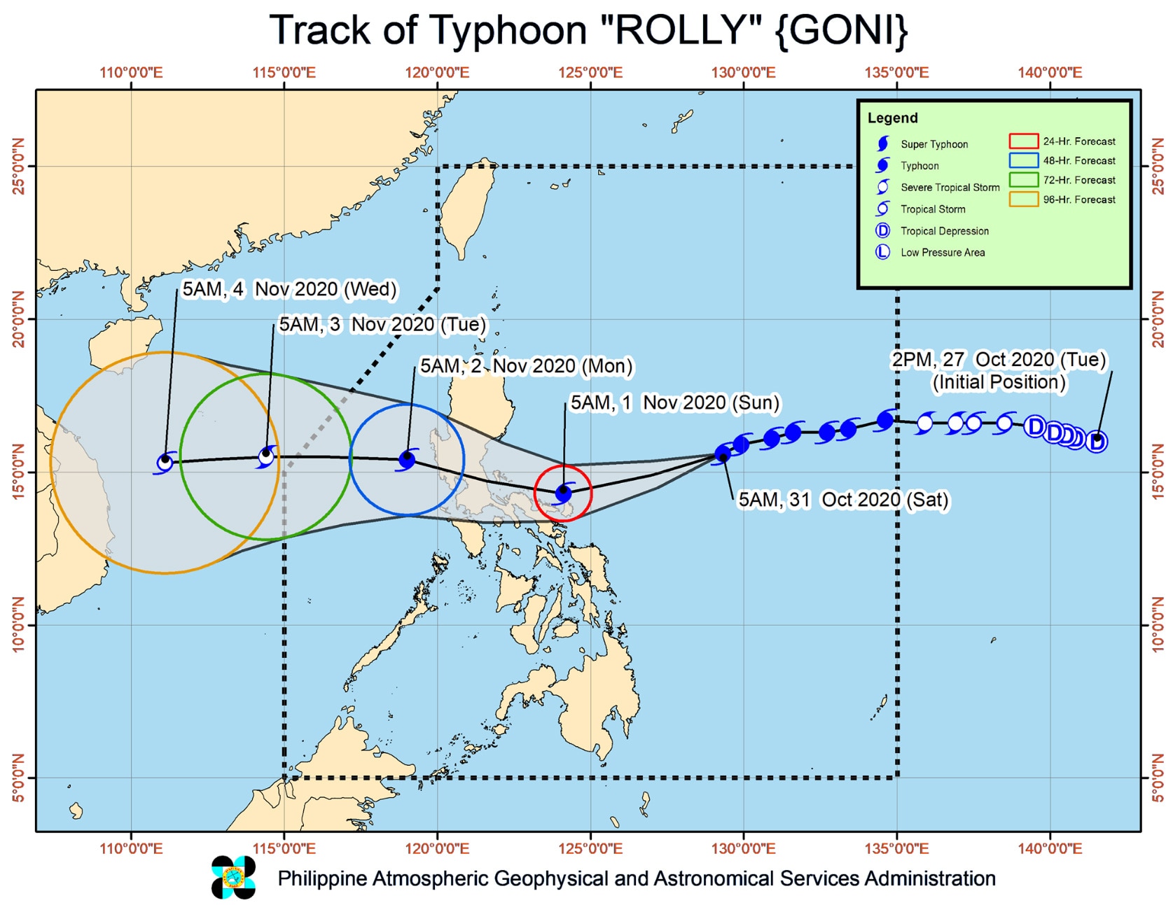
MANILA (UPDATE) Typhoon Rolly maintained its strength early Saturday morning as it churned closer towards the Bicol Region, remaining on track to become a super typhoon, state weather bureau PAGASA said.
MANILA (UPDATE) Typhoon Rolly maintained its strength early Saturday morning as it churned closer towards the Bicol Region, remaining on track to become a super typhoon, state weather bureau PAGASA said.
The tropical cyclone, the world's strongest so far this year, was packing maximum sustained winds of 215 kilometers per hour near the center and gusts of up to 265 kph as of 8 a.m., according to PAGASA.
The tropical cyclone, the world's strongest so far this year, was packing maximum sustained winds of 215 kilometers per hour near the center and gusts of up to 265 kph as of 8 a.m., according to PAGASA.
Under PAGASA's classification, a super typhoon carries maximum wind speeds of at least 220 kph.
Under PAGASA's classification, a super typhoon carries maximum wind speeds of at least 220 kph.
PAGASA said it is more likely to be near super typhoon strength by the time it grazes the Bicol Region and makes landfall over Quezon.
PAGASA said it is more likely to be near super typhoon strength by the time it grazes the Bicol Region and makes landfall over Quezon.
ADVERTISEMENT
Typhoon Rolly's center was last spotted 540 kilometers east northeast of Virac, Catanduanes and was moving westward at 20 kph.
Typhoon Rolly's center was last spotted 540 kilometers east northeast of Virac, Catanduanes and was moving westward at 20 kph.
Starting Sunday morning, it will gradually turn west-northwest, bringing its inner rainbands-eyewall region near or over Catanduanes and Camarines provinces in the morning and over Quezon-southern Aurora area in the late afternoon through evening, PAGASA said.
Starting Sunday morning, it will gradually turn west-northwest, bringing its inner rainbands-eyewall region near or over Catanduanes and Camarines provinces in the morning and over Quezon-southern Aurora area in the late afternoon through evening, PAGASA said.
The center of the eye of the typhoon is forecast to pass very close to Catanduanes, over the Calaguas Islands and very close to mainland Camarines Provinces by Sunday morning and over Polillo Islands and mainland Quezon Sunday afternoon or early evening.
The center of the eye of the typhoon is forecast to pass very close to Catanduanes, over the Calaguas Islands and very close to mainland Camarines Provinces by Sunday morning and over Polillo Islands and mainland Quezon Sunday afternoon or early evening.
PAGASA said it was not ruling out a landfall scenario in Catanduanes and the Camarines provinces due to the proximity of the forecast track to the Bicol region.
PAGASA said it was not ruling out a landfall scenario in Catanduanes and the Camarines provinces due to the proximity of the forecast track to the Bicol region.
Violent winds and intense rainfall associated with the inner rainband-eyewall region will be experienced over Catanduanes, Camarines Norte, and the northern portion of Camarines Sur early Sunday morning through afternoon, and over Quezon and the southern portion of Aurora by Sunday afternoon through evening.
Violent winds and intense rainfall associated with the inner rainband-eyewall region will be experienced over Catanduanes, Camarines Norte, and the northern portion of Camarines Sur early Sunday morning through afternoon, and over Quezon and the southern portion of Aurora by Sunday afternoon through evening.
ADVERTISEMENT
It will next cross Central Luzon, before exiting the Luzon landmass on Monday morning.
It will next cross Central Luzon, before exiting the Luzon landmass on Monday morning.
The tropical cyclone is forecast to weaken as a severe tropical storm or a minimal typhoon until it emerges over the West Philippine Sea, PAGASA said.
The tropical cyclone is forecast to weaken as a severe tropical storm or a minimal typhoon until it emerges over the West Philippine Sea, PAGASA said.
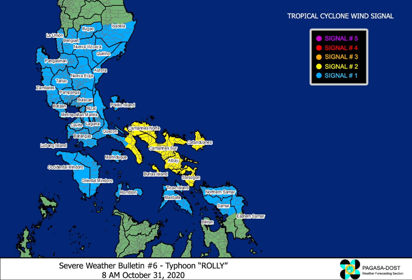
Tropical Cyclone Wind Signal (TCWS) No. 2 has been hoisted over the following areas, which will experience 61 kph-120 kph winds in 24 hours:
Tropical Cyclone Wind Signal (TCWS) No. 2 has been hoisted over the following areas, which will experience 61 kph-120 kph winds in 24 hours:
- Catanduanes
- Camarines Norte
- Camarines Sur
- Albay
- Sorsogon
- Burias Island
- Southeastern portion of Quezon (San Francisco, San Andres, San Narciso, Mulanay, Catanauan, Buenavista, Lopez, Guinayangan, Calauag, Tagkawayan)
- Catanduanes
- Camarines Norte
- Camarines Sur
- Albay
- Sorsogon
- Burias Island
- Southeastern portion of Quezon (San Francisco, San Andres, San Narciso, Mulanay, Catanauan, Buenavista, Lopez, Guinayangan, Calauag, Tagkawayan)
Tropical Cyclone Wind Signal (TCWS) No. 1 was also raised over the following areas, which will experience 30 kph-60 kph winds in 36 hours:
Tropical Cyclone Wind Signal (TCWS) No. 1 was also raised over the following areas, which will experience 30 kph-60 kph winds in 36 hours:
LUZON:
LUZON:
ADVERTISEMENT
- The rest of Masbate including Ticao Island,
- The rest of Quezon including Polillo Islands
- Rizal
- Laguna
- Cavite
- Batangas
- Marinduque
- Romblon
- Occidental Mindoro including Lubang Island
- Oriental Mindoro
- Metro Manila
- Bulacan
- Pampanga
- Bataan
- Zambales
- Tarlac
- Nueva Ecija
- Aurora
- Pangasinan
- La Union
- Benguet
- Ifugao
- Nueva Vizcaya
- Quirino
- the southern portion of Isabela (Aurora, Luna, Reina Mercedes, Naguilian, Benito Soliven, San Mariano, Palanan, Dinapigue, San Guillermo, Echague, San Agustin, Jones, Cordon, Santiago City, Ramon, San Isidro, Angadanan, Alicia, Cauayan City, Cabatuan, San Mateo)
VISAYAS:
VISAYAS:
- Northern Samar
- Northern portion of Samar (Tagapul-An, Almagro, Santo Nino, Tarangnan, Catbalogan City, Calbayog City, Santa Margarita, Gandara, Pagsanghan, San Jorge, Jiabong, Motiong, Paranas, San Jose de Buan, Matuguinao)
- Northern portion of Eastern Samar (Taft, Can-Avid, Dolores, Maslog, Jipapad, Arteche, Oras, San Policarpo)
- Northern portion of Biliran (Kawayan, Maripipi)
Starting Saturday night until Sunday, heavy to intense rains will be experienced over Catanduanes, Camarines Norte, Camarines Sur, Albay, Burias Island, Calabarzon, Metro Manila, Bulacan, Pampanga, Bataan, Zambales and Tarlac.
Starting Saturday night until Sunday, heavy to intense rains will be experienced over Catanduanes, Camarines Norte, Camarines Sur, Albay, Burias Island, Calabarzon, Metro Manila, Bulacan, Pampanga, Bataan, Zambales and Tarlac.
Moderate to heavy rains will be experienced over Marinduque, Romblon, Occidental Mindoro, Oriental Mindoro, Northern Samar, mainland Cagayan Valley, and the rest of the Bicol region and Central Luzon.
Moderate to heavy rains will be experienced over Marinduque, Romblon, Occidental Mindoro, Oriental Mindoro, Northern Samar, mainland Cagayan Valley, and the rest of the Bicol region and Central Luzon.
The typhoon may also trigger storm surge of up to 3 meters over the northern coastal areas of Quezon including Polillo Islands and up to 2 meters over the coastal areas of Aurora, Marinduque, Bicol Region, and Northern Samar and the other coastal areas of Quezon in the next 48 hours, PAGASA warned.
The typhoon may also trigger storm surge of up to 3 meters over the northern coastal areas of Quezon including Polillo Islands and up to 2 meters over the coastal areas of Aurora, Marinduque, Bicol Region, and Northern Samar and the other coastal areas of Quezon in the next 48 hours, PAGASA warned.
Meanwhile, PAGASA said Tropical Depression Atsani, a weather disturbance outside the Philippine area of responsibility (PAR), is not likely to affect any portion of the country over the next 3 days.
Meanwhile, PAGASA said Tropical Depression Atsani, a weather disturbance outside the Philippine area of responsibility (PAR), is not likely to affect any portion of the country over the next 3 days.
ADVERTISEMENT
It was last spotted 1,600 kms east of Visayas and is currently packing maximum sustained winds of 55 kph near the center and gusts of up to 70 kph.
It was last spotted 1,600 kms east of Visayas and is currently packing maximum sustained winds of 55 kph near the center and gusts of up to 70 kph.
Atsani is moving west-northwestward at 25 kph and is forecast to enter the PAR Sunday afternoon.
Atsani is moving west-northwestward at 25 kph and is forecast to enter the PAR Sunday afternoon.
Visit the ABS-CBN Weather Center for updates.
ADVERTISEMENT
ADVERTISEMENT