Welcome, Kapamilya! We use cookies to improve your browsing experience. Continuing to use this site means you agree to our use of cookies. Tell me more!
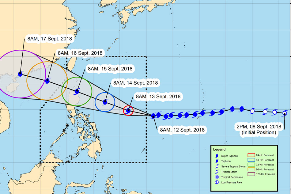
The track of Typhoon Ompong. From the PAGASA website
MANILA - Typhoon Ompong (international name Mangkhut) has entered the Philippine area of responsibility, the state weather bureau said Wednesday afternoon.
In its 11:00 a.m. advisory, PAGASA said Ompong has intensified, packing 205-kph winds and gusts of up to 255 kph.
The typhoon, the strongest to hit the country so far this year, remains on track towards the Cagayan-Batanes area, moving west at 20 kph, the weather agency said.
PAGASA said Ompong has no direct effect to the country yet but it is expected to make its presence felt by Thursday.
ADVERTISEMENT
The state weather bureau earlier said Ompong may peak at 220 kph in maximum sustained winds with gustiness of 270 kph. PAGASA classifies a cyclone with top sustained winds of over 220 kph as a supertyphoon.
Ompong is expected to enhance the southwest monsoon (habagat) and may bring rains that will match or even exceed the level of Tropical Storm Ondoy, the state weather bureau said.
Ondoy had caused unprecedented flooding and devastation in Metro Manila in 2009.
Heavy rains due to the enhanced habagat are expected over Zamboanga Peninsula, Northern Mindanao, Siquijor, Surigao del Norte, Agusan del Norte, Dinagat Island, and Lanao del Sur.
Rains triggered by the enhanced monsoon will move north as the typhoon moves closer to the country, Pagasa said.
ADVERTISEMENT
Senior weather specialist Chris Perez also warned of "very strong winds" and 6-meter high storm surges in coastal areas along the path of the typhoon in northern Luzon by Friday and Saturday.
He said the weather bureau may begin raising cyclone warning signals over affected areas on Wednesday afternoon. Schools in some of these areas already suspended Thursday classes.
ABS-CBN is the leading media and entertainment company in the Philippines, offering quality content across TV, radio, digital, and film. Committed to public service and promoting Filipino values, ABS-CBN continues to inspire and connect audiences worldwide.
Our website is made possible by displaying online
advertisements to our visitors. Please consider supporting
us by disabling your ad blocker on our website.
Our website is made possible by displaying online
advertisements to our visitors. Please consider supporting
us by disabling your ad blocker on our website.