Welcome, Kapamilya! We use cookies to improve your browsing experience. Continuing to use this site means you agree to our use of cookies. Tell me more!
'Goring' maintains strength on way out of Philippine area
'Goring' maintains strength on way out of Philippine area
ABS-CBN News
Published Aug 30, 2023 06:13 PM PHT
|
Updated Aug 30, 2023 11:43 PM PHT
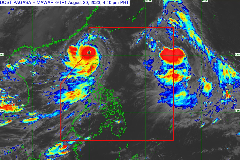
PAGASA image
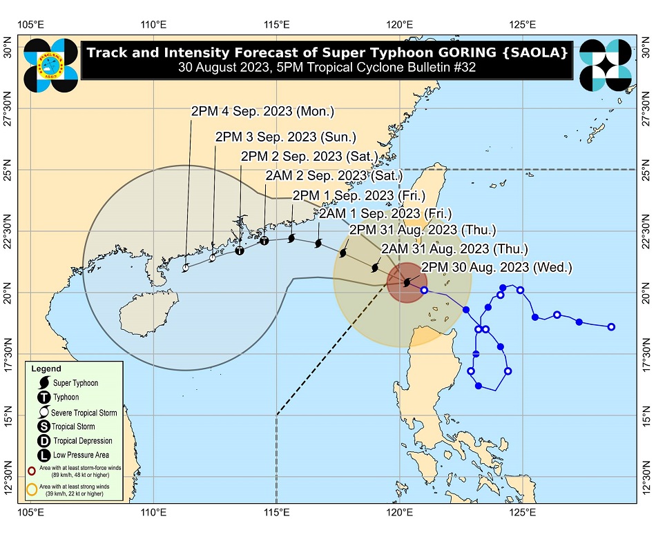
MANILA — Super typhoon Goring (international name: Saola) maintained its strength as it approached the boundary of the Philippine area of responsibility on Wednesday afternoon, the state weather bureau said.
In its 5 p.m. weather bulletin, PAGASA said Goring was spotted 185 kilometers west of Itbayat, Batanes, packing maximum sustained winds of 195 kilometers per hour near the center and up to 240 kp gusts.
Moving at 15 kph, Goring is expected to continue in a west northwestward direction across the Luzon Strait until it exits the Philippine area of responsibility between Wednesday evening or Thursday morning.
Goring may dump between 100 to 200 millimeters (around 4 to 8 inches) of rainfall over Batanes, Babuyan Islands, Ilocos Norte, the northern portion of Apayao, and the extreme northwestern portion of mainland Cagayan until Thursday afternoon.
ADVERTISEMENT
Ilocos Sur, Abra, the northwestern portion of mainland Cagayan, and the rest of Apayao, on the other hand, may experience between 50 to 100 mm (2 to 4 inches) of rainfall.
"Under these conditions, flooding and rain-induced landslides are possible especially in areas that are highly or very highly susceptible to these hazards," PAGASA warned.
Goring will also enhance the southwest monsoon, which will bring occasional rains over the western portions of Central Luzon, Southern Luzon, and Visayas over the next three days, PAGASA said.
Tropical Cyclone Wind Signal No. 1 remains hoisted over the following areas, which may experience wind speeds of 39 to 61 kph within the next 36 hours.
Batanes
Babuyan Islands
Ilocos Norte
Northern portion of Apayao (Luna, Santa Marcela, Calanasan)
Northwestern portion of Cagayan (Pamplona, Claveria, Ballesteros, Abulug, Sanchez-Mira, Santa Praxedes)
Meanwhile, the tropical storm outside of PAR, with the international name Haikui, maintained its strength as it approached PAR.
ADVERTISEMENT
As of 10 a.m., it is located 1,465 kilometers east of extreme northern Luzon.
PAGASA said it could enter PAR by Wednesday afternoon or evening and would be assigned the local name “Hanna.”
It is forecast to remain far from the Philippine landmass and may exit PAR by Friday.
Although it is less likely to directly affect the country, PAGASA said it may enhance the habagat beginning Thursday, and may bring occasional or monsoon rains over the western portion of Luzon and Visayas.
ABS-CBN is the leading media and entertainment company in the Philippines, offering quality content across TV, radio, digital, and film. Committed to public service and promoting Filipino values, ABS-CBN continues to inspire and connect audiences worldwide.
Our website is made possible by displaying online
advertisements to our visitors. Please consider supporting
us by disabling your ad blocker on our website.
Our website is made possible by displaying online
advertisements to our visitors. Please consider supporting
us by disabling your ad blocker on our website.