Welcome, Kapamilya! We use cookies to improve your browsing experience. Continuing to use this site means you agree to our use of cookies. Tell me more!
Auring maintains strength over Philippine Sea, Signal No. 1 up in 25 areas
Auring maintains strength over Philippine Sea, Signal No. 1 up in 25 areas
ABS-CBN News
Published Feb 20, 2021 12:06 PM PHT
|
Updated Feb 20, 2021 06:46 PM PHT
PAGASA
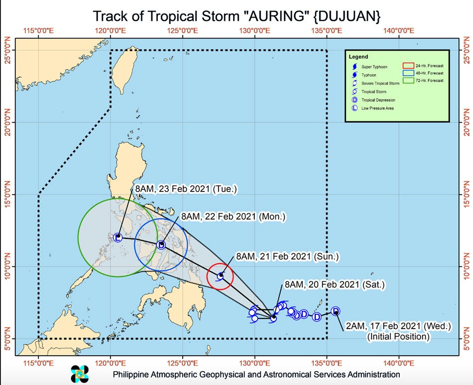
MANILA - Tropical Storm Auring has maintained its strength over the Philippine Sea east of Mindanao, the state weather bureau said Saturday, as it moved towards the country's landmass with landfall expected Sunday.
In its 11 a.m. bulletin, PAGASA said Auring was located 595 kilometers east southeast of Hinatuan, Surigao del Sur as of 10 a.m., packing maximum sustained winds of 75 kilometers per hour near the center and gustiness of up to 90 kph.
Tropical Cyclone Wind Signal No. 1, where winds of 30 to 60 kph, which may cause light damage to high-risk structures, may be expected within 36 hours, was raised over the following areas:
ADVERTISEMENT
VISAYAS
Northern Samar
Eastern Samar
Samar
Biliran
Leyte
Southern Leyte
Cebu
Negros Oriental
Bohol
Siquijor
MINDANAO:
Dinagat Islands
Surigao del Norte
Surigao del Sur
Agusan del Norte
Agusan del Sur
Davao Oriental
Davao de Oro
Davao del Norte
Davao City
Camiguin
Misamis Oriental
Misamis Occidental
Lanao del Norte
Bukidnon
Lanao del Sur
PAGASA said the combined effects of the surge of the northeast monsoon and Auring will bring strong to gale-force winds over the areas where storm signal warning No. 1 is in effect.
It will also impact the rest of Visayas, Bicol Region, Calabarzon, Mindoro Provinces, Marinduque, Romblon, and the northern portion of Palawan (including Calamian, Cuyo, and Kalayaan Islands). Strong breeze to near-gale conditions are also likely over the rest of Luzon.
The storm is forecast to gradually move northwestward in the next 12 hours before accelerating.
PAGASA said Auring is expected to make landfall over the eastern coast of Caraga Region on Sunday afternoon or evening before crossing Visayas and MIMAROPA throughout the remainder of Sunday through Monday.
The weather bureau said Auring is likely to remain a tropical storm until it makes landfall. It may also weaken into a tropical depression before it hits land.
ADVERTISEMENT
From Saturday to Sunday, heavy to intense rains may persist over Surigao del Norte, Surigao del Sur, Dinagat Islands, and Eastern Samar.
Moderate to heavy with at times intense rains may be experienced over Misamis Oriental, Camiguin, and the rest of Caraga.
Light to moderate with at times heavy rains may persist over Central Visayas, Davao Oriental, Davao de Oro, Davao del Norte, and the rest of Northern Mindanao and Eastern Visayas.
Residents in flood-prone and landslide-prone areas are advised to monitor the weather bulletins and take appropriate action should flooding occur.
ABS-CBN is the leading media and entertainment company in the Philippines, offering quality content across TV, radio, digital, and film. Committed to public service and promoting Filipino values, ABS-CBN continues to inspire and connect audiences worldwide.
Our website is made possible by displaying online
advertisements to our visitors. Please consider supporting
us by disabling your ad blocker on our website.
Our website is made possible by displaying online
advertisements to our visitors. Please consider supporting
us by disabling your ad blocker on our website.